|
CHAPTER 12
LAKE TITICACA AND CORDILLERA CARABAYA
Lake Titicaca is an icon of South America.
At 3810 m above sea level, the highest
navigable lake in the world occupies
8562 sq km, straddling the border between
Peru and Bolivia. This natural lake is a
major tourist destination, especially along
the south shore. The less-visited north side
of the lake is gently hilly with many rocky
promontories, beaches, and sheltered bays
rich in birdlife. Scattered about the lake are
seventy-two islands. The flat areas around
the lake are known as punas.
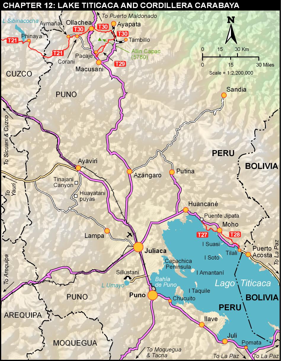
To the north and west of the lake is the
remote and isolated Cordillera Carabaya,
the watershed between the Titicaca
and Amazon basins, connecting the
Cordillera Vilcanota in Cuzco with the
Cordillera Apolobamba in Bolivia. This
region has beautiful glaciated mountains
crowned by Allin Capac (5780 m), spectacular
lakes, undeveloped archaeological
sites, ancient roads, rock forests, and rock
art. It has been a mining area since at least
Inca times and is Peru’s largest alpaca
producer with huge herds grazing the
punas. Trekking here requires strong navigation
skills, good Spanish, and patient
cross-cultural communication. Most
Carabaya residents are unfamiliar with
trekking and will assume you are a prospector
or up to some sort of mischief. It
is well worth the time and effort required
to break the ice
...
Trek 27
PUENTE JIPATA TO MOHO
GENTLE OMASUYO

THE NORTH SHORE OF Lake Titicaca was the Omasuyo region of the Incas. It has
many ancient roads and the remains of several pre-Inca settlements. Following these
roads through the terraced slopes above the lakeshore, this gentle trek offers a glimpse
into the traditional lives of the rural Aymara people, closely tied to the land and water.
The humidity released by evaporation from the lake and the fact that the water absorbs
heat and releases it at night, tempers the harsh climate of the surrounding altiplano.
This creates micro-climates that allow the cultivation of fruits, vegetables, and flowers
typical of lower, warmer elevations. Moho, the regional center at the end of this trek,
proudly calls itself el jardín del altiplano, "the garden of the altiplano". Floating trout
farms are common offshore, and in October or November you might see small boats
going out at night to fish the schools of tiny endemic ispi, with traditional reed fishing
baskets now replaced by nylon nets
...
Trek 28
MOHO TO TILALI
TAURANI TREK
AT FIRST GLANCE, HIKING the gently rolling hills along the shore of Lake
Titicaca might seem very easy. This trek, however, follows not only ancient and modern
roads through Aymara villages scattered over the wide open landscape, it also heads
cross-country along surprisingly steep ridgelines and across deep quebradas. Substantial
navigational challenge likewise makes this route more difficult than you might expect
...
Trek 29
ALLIN CAPAC LAKES
TARUCA TREK
THE TWO MOST EMBLEMATIC summits of the Cordillera Carabaya are Allin
Capac (Allinccapac, Allinjapac, 5780 m) and Chichi Capac (Chichiccapac, 5614 m),
striking features of both the landscape and local mythology. For many people they
remain venerated apus, mountain deities to which tributes are offered in order to propitiate
a bountiful harvest or multiplication of the alpaca herd. At the foot of these two
giants lies a chain of particularly beautiful lakes in a glacial valley flowing from vertical
rock faces to the flat puna.
The gorgeous scenery is complemented by a rich variety of fauna, including
many water birds and large mammals ranging from large herds of domestic llamas and
alpacas, through shy wild vicuñas, to taruca (Hippocamelus antisensis)—the stately highaltitude
Andean deer
...
Trek 30
CARABAYA TRAVERSE
ALL AROUND ALLIN CAPAC
YOU CANNOT TREK MUCH farther off the tourist trail in Peru than this route. It
takes in a cross-section of real life in the Cordillera Carabaya ranging from the sublime
to the squalid, from views of the immense glaciers of Quelcaya to the mine-marred
landscape around Ollachea. Along the way are a long list of natural and man-made wonders,
as well as a few disappointments. A river vanishes before your eyes while another
divides straddling a ridge. You travel difficult cross-country routes along seemingly
endless chains of lakes, ancient roads that once led to the Inca’s own mines, wide trails
marked with milestones, and brand-new vehicle tracks that have just wrecked one of
the above. A highlight is the pre-Inca Pitumarka archaeological site, reached by a stone
stairway through a waterfall. All the while you are making a wide circumnavigation of
Allin Capac (5780 m), the senior apu of Carabaya
...
|


